
1898 Map of Chester
USGS Topo · Published 1898About this map
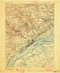
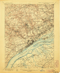
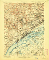
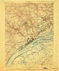
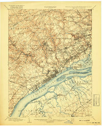
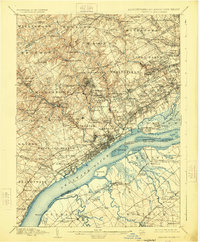
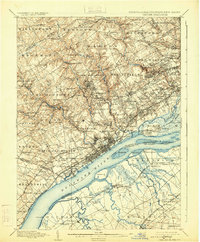
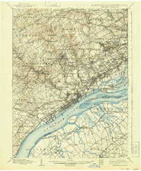
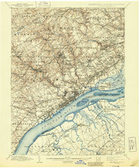
The industrial and riparian corridor of the Delaware River anchors this 1894 survey, documenting the transition from maritime trade to suburban expansion across Chester County and Delaware County. The city of Chester sits at the center of a dense network of iron and wood, where the Baltimore and Ohio R. R. and Reading R. R. converge near the waterfront. Beyond the urban core, the landscape is defined by the milling economy along Crum Creek, Ridley Creek, and Chester Creek, featuring sites like Lenni Mills, Llewellyn Mills, and Ivy Mills. Significant social institutions of the Victorian era are prominently marked, including the Williamson School and the House of Refuge. To the south, the map details the river's navigational hazards and islands, such as Little Tinicum Id. and Raccoon Id., alongside established riverfront settlements like Marcus Hook and Trainer.
Find a feature on this map
197 named features on this map. Tap any name to fly to it.
Don’t see what you’re looking for? This feature index may not catch every label — zoom into the map to look around manually.
Map Details
Editions of this 1898 Chester Map
10 editions found
Other maps of this area

1890 · Salem
USGS Topo · 1:62,500

1890 · Glassboro
USGS Topo · 1:62,500

1891 · Philadelphia
USGS Topo · 1:62,500

1893 · Germantown
USGS Topo · 1:62,500

1894 · Chester
USGS Topo · 1:62,500

1894 · Philadelphia
USGS Topo · 1:62,500

1894 · Norristown
USGS Topo · 1:62,500

1894 · Germantown
USGS Topo · 1:62,500

1895 · Norristown
USGS Topo · 1:62,500

1896 · Germantown
USGS Topo · 1:62,500