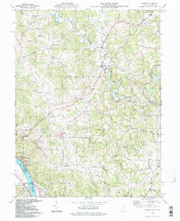
1994 Map of Chester
USGS Topo · Published 1998About this map
The Ohio River forms the southern boundary of this region, where industrial riverside towns like Syracuse and Hartford are set against a backdrop of deep valleys and creek systems. Further inland, the map shows a landscape defined by small clusters and family settlements such as the Nease Settlement and Welsh Town. The confluence of the West Branch, Middle Branch, and East Branch of the Shade River dominates the northern half of the sheet, winding through the townships of Bedford and Chester. Local life is anchored by institutions like the Eastern High School and several rural sanctuaries, including Mt Herman Ch and St Johns Ch. Evidence of the area's extraction history is visible near the river, where a Strip Mine sits near Forest Run.
Find a feature on this map
73 named features on this map. Tap any name to fly to it.
Don’t see what you’re looking for? This feature index may not catch every label — zoom into the map to look around manually.
Map Details
Editions of this 1994 Chester Map
This is the sole edition of this map. No revisions or reprints were ever made.
Other maps of this area

1907 · Pomeroy
USGS Topo · 1:62,500

1907 · Keno
USGS Topo · 1:62,500

1908 · Ravenswood
USGS Topo · 1:62,500

1908 · Point Pleasant
USGS Topo · 1:62,500

1926 · Ravenswood
USGS Topo · 1:62,500

1926 · Point Pleasant
USGS Topo · 1:62,500

1928 · Ravenswood
USGS Topo · 1:62,500

1929 · Point Pleasant
USGS Topo · 1:62,500

1947 · Columbus
USGS Topo · 1:250,000

1949 · Clarksburg
USGS Topo · 1:250,000