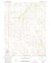
1960 Map of Chester
USGS Topo · Published 1980About this map
Chester sits prominently on the Nebraska side of the state line, serving as a hub for the agricultural plains along the Burlington Northern railroad. The landscape is marked by the seasonal drainage of Dry Creek and the meandering path of Rose Creek, which cuts across the southern portion of the map near the Hubbell settlement. This survey, updated with 1978 data, reveals a network of rural education and memorial sites, including Sylvan View Sch and School No 77. The presence of Chester Cem, St Johns Cem, and Hubbell Cem provides valuable location data for genealogists tracing families in the townships of Hebron, Liberty, and Hubbell. The map captures the organized section-line road system that has defined this border region since the initial surveys.
Find a feature on this map
21 named features on this map. Tap any name to fly to it.
Don’t see what you’re looking for? This feature index may not catch every label — zoom into the map to look around manually.
Map Details
Editions of this 1960 Chester Map
2 editions found
Other maps of this area

1892 · Concordia
USGS Topo · 1:125,000

1893 · Washington
USGS Topo · 1:125,000

1898 · Hebron
USGS Topo · 1:125,000

1955 · Manhattan
USGS Topo · 1:250,000

1955 · Lincoln
USGS Topo · 1:250,000

1956 · Manhattan
USGS Topo · 1:250,000

1957 · Manhattan
USGS Topo · 1:250,000

1957 · Lincoln
USGS Topo · 1:250,000

1958 · Lincoln
USGS Topo · 1:250,000

1960 · Chester
USGS Topo · 1:24,000