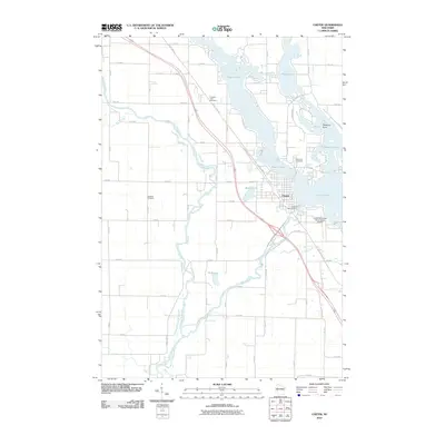
2010 Map of Chetek
USGS Topo · Published 2010About this map
Prairie Lake and Lake Chetek dominate this landscape in Barron County, forming a complex waterway regulated by the Chetek WP277 Dam. The city of Chetek serves as the central hub, positioned between these significant water bodies and the winding Red Cedar River. The local geography is defined by its glacial lake system, including Mud Lake, Bailey Lake, and Pokegama Lake, which are interspersed with residential and agricultural grids.
Find a feature on this map
63 named features on this map. Tap any name to fly to it.
Don’t see what you’re looking for? This feature index may not catch every label — zoom into the map to look around manually.
Map Details
Editions of this 2010 Chetek Map
This is the sole edition of this map. No revisions or reprints were ever made.
Other maps of this area

1949 · New Auburn
USGS Topo · 1:62,500

1949 · Ridgeland
USGS Topo · 1:62,500

1951 · Ridgeland
USGS Topo · 1:62,500

1951 · New Auburn
USGS Topo · 1:62,500

1951 · Chetek
USGS Topo · 1:62,500

1951 · Barron
USGS Topo · 1:62,500

1953 · Rice Lake
USGS Topo · 1:250,000

1959 · Rice Lake
USGS Topo · 1:250,000
1975 · New Auburn
USGS Topo · 1:24,000
1975 · Sand Creek
USGS Topo · 1:24,000