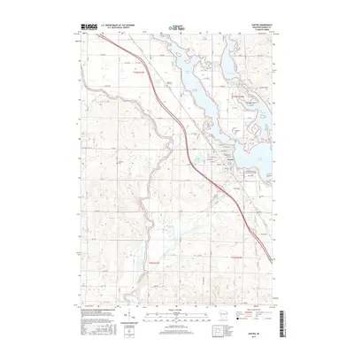
2015 Map of Chetek
USGS Topo · Published 2015About this map
The city of Chetek sits at the heart of this Barron County landscape, where the Chetek River flows from the southern end of Lake Chetek. This area is defined by an intricate network of waterways, including Prairie Lake, Mud Lake, and the winding Red Cedar River. The settlement pattern follows the contours of the shoreline and the local road system, which includes the historical placements of the Pleasant Plain Cem, Otterholt Cem, and Lakeview Cem.
Find a feature on this map
65 named features on this map. Tap any name to fly to it.
Don’t see what you’re looking for? This feature index may not catch every label — zoom into the map to look around manually.
Map Details
Editions of this 2015 Chetek Map
This is the sole edition of this map. No revisions or reprints were ever made.
Other maps of this area

1949 · New Auburn
USGS Topo · 1:62,500

1949 · Ridgeland
USGS Topo · 1:62,500

1951 · Ridgeland
USGS Topo · 1:62,500

1951 · New Auburn
USGS Topo · 1:62,500

1951 · Chetek
USGS Topo · 1:62,500

1951 · Barron
USGS Topo · 1:62,500

1953 · Rice Lake
USGS Topo · 1:250,000

1959 · Rice Lake
USGS Topo · 1:250,000
1975 · New Auburn
USGS Topo · 1:24,000
1975 · Sand Creek
USGS Topo · 1:24,000