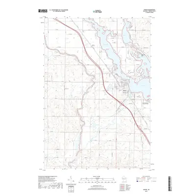
2018 Map of Chetek
USGS Topo · Published 2018About this map
Chetek serves as the hub of this lakeside landscape, where the waters of Prairie Lake, Lake Chetek, and the Chetek River converge. The town's grid is well-defined by streets such as W Stout St and Knapp St, and the local infrastructure includes the Chetek Municipal-Southworth Airport on the eastern outskirts. For genealogists, the map identifies three significant burial sites: Pleasant Plain Cem, Otterholt Cem, and Lakeview Cem, each situated in a different quadrant of the township.
Find a feature on this map
97 named features on this map. Tap any name to fly to it.
Don’t see what you’re looking for? This feature index may not catch every label — zoom into the map to look around manually.
Map Details
Editions of this 2018 Chetek Map
This is the sole edition of this map. No revisions or reprints were ever made.
Other maps of this area

1949 · New Auburn
USGS Topo · 1:62,500

1949 · Ridgeland
USGS Topo · 1:62,500

1951 · Ridgeland
USGS Topo · 1:62,500

1951 · New Auburn
USGS Topo · 1:62,500

1951 · Chetek
USGS Topo · 1:62,500

1951 · Barron
USGS Topo · 1:62,500

1953 · Rice Lake
USGS Topo · 1:250,000

1959 · Rice Lake
USGS Topo · 1:250,000
1975 · New Auburn
USGS Topo · 1:24,000
1975 · Sand Creek
USGS Topo · 1:24,000