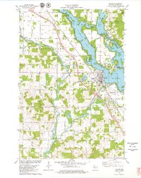
1978 Map of Chetek
USGS Topo · Published 1979About this map
Chetek serves as the focal point for this Barron County landscape, positioned where the Chetek River meets a sprawling network of glacial water bodies. The intricate shoreline is defined by Lake Chetek, Prairie Lake, and Pokegama Lake, connected by navigable passages like The Narrows and Pike Slough. This mid-1970s survey illustrates a region shaped by both its timber-and-transit history and its evolution into a recreational hub, with the Chicago and North Western railroad corridor cutting northwest past Pittmans Point.
Find a feature on this map
36 named features on this map. Tap any name to fly to it.
Don’t see what you’re looking for? This feature index may not catch every label — zoom into the map to look around manually.
Map Details
Editions of this 1978 Chetek Map
This is the sole edition of this map. No revisions or reprints were ever made.
Other maps of this area

1949 · New Auburn
USGS Topo · 1:62,500

1949 · Ridgeland
USGS Topo · 1:62,500

1951 · Ridgeland
USGS Topo · 1:62,500

1951 · New Auburn
USGS Topo · 1:62,500

1951 · Chetek
USGS Topo · 1:62,500

1951 · Barron
USGS Topo · 1:62,500

1953 · Rice Lake
USGS Topo · 1:250,000

1959 · Rice Lake
USGS Topo · 1:250,000
1975 · New Auburn
USGS Topo · 1:24,000
1975 · Sand Creek
USGS Topo · 1:24,000