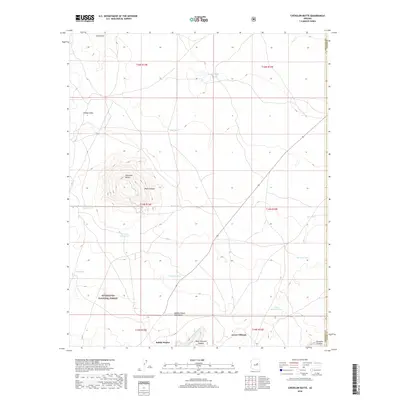
2018 Map of Chevelon Butte
USGS Topo · Published 2018About this map
Chevelon Butte rises from the high desert of Coconino County, serving as the central landmark for this arid landscape near the Coconino and Navajo County boundary. The terrain is marked by deep incisions from Chevelon Canyon and its tributaries, including W Chevelon Cr and West Chevelon Canyon. This 2018 survey reveals a landscape largely managed for conservation and ranching, with the southern portion dedicated to the Sitgreaves National Forest. Human presence is evidenced primarily by water infrastructure necessary for livestock and wildlife in the high country, including Babbitt Tank, Mormon Tank, and the Babbitt Water Catchment. Family-named landmarks such as Babbit Winter, Tillman Draw, and Lower Tillman suggest the long-standing ranching history that has shaped the land's usage.
Find a feature on this map
27 named features on this map. Tap any name to fly to it.
Don’t see what you’re looking for? This feature index may not catch every label — zoom into the map to look around manually.
Map Details
Editions of this 2018 Chevelon Butte Map
This is the sole edition of this map. No revisions or reprints were ever made.
Other maps of this area

1886 · Holbrook
USGS Topo · 1:250,000

1893 · Holbrook
USGS Topo · 1:250,000

1954 · Holbrook
USGS Topo · 1:250,000

1955 · Sunset Knoll 2 SW
USGS Topo · 1:24,000

1955 · Sunset Knoll 2 SE
USGS Topo · 1:24,000

1955 · Sunset Pass
USGS Topo · 1:62,500

1957 · Holbrook
USGS Topo · 1:250,000

1958 · Holbrook
USGS Topo · 1:250,000

1960 · Holbrook
USGS Topo · 1:250,000
1965 · Grama Draw
USGS Topo · 1:24,000