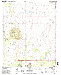
1998 Map of Chevelon Butte
USGS Topo · Published 2000About this map
Chevelon Butte dominates this landscape on the boundary of the Sitgreaves National Forest, providing a high-elevation anchor for the surrounding arid terrain. The map documents a remote region of Northern Arizona where livestock and water management are the primary drivers of human activity. A dense network of man-made watering holes, such as Little Mormon Tank, Broken Tank, and Highway Tank, indicates the critical importance of range management for cattle operations in this high-desert environment. The presence of the Babbitt Winter Ranch near the southern border highlights the long-standing influence of the Babbitt family, a prominent name in Arizona ranching history. Transportation across the mesa is defined by the Heber Winslow Highway and Tillman Road, which skirt the volcanic features and the deep incisions of Chevelon Canyon and Pablo Canyon. Industry is represented by the Bassett Quarry, while modern infrastructure appears via the Chevelon Communication Site atop the butte.
Find a feature on this map
27 named features on this map. Tap any name to fly to it.
Don’t see what you’re looking for? This feature index may not catch every label — zoom into the map to look around manually.
Map Details
Editions of this 1998 Chevelon Butte Map
This is the sole edition of this map. No revisions or reprints were ever made.
Other maps of this area

1886 · Holbrook
USGS Topo · 1:250,000

1893 · Holbrook
USGS Topo · 1:250,000

1954 · Holbrook
USGS Topo · 1:250,000

1955 · Sunset Knoll 2 SW
USGS Topo · 1:24,000

1955 · Sunset Knoll 2 SE
USGS Topo · 1:24,000

1955 · Sunset Pass
USGS Topo · 1:62,500

1957 · Holbrook
USGS Topo · 1:250,000

1958 · Holbrook
USGS Topo · 1:250,000

1960 · Holbrook
USGS Topo · 1:250,000
1965 · Grama Draw
USGS Topo · 1:24,000