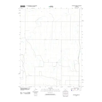
2009 Map of Cheyenne Creek
USGS Topo · Published 2009About this map
The Smoky Hill River winds across the northern reaches of this Kansas landscape, defining a drainage system that includes Cheyenne Creek and the various branches of Salt Creek. This 2009 survey by the U.S. Geological Survey captures a sparsely populated region of Lane County characterized by an expansive network of rural county roads. The intersection of Gove C and Dodge Rd anchors the northwestern corner, while State Hwy 23 provides the primary north-south transit corridor along the eastern edge. The topography is defined by the subtle valleys of West Salt Creek and East Salt Creek, illustrating the intricate water-carved patterns typical of the High Plains. This map is an essential reference for understanding the modern rural infrastructure and natural hydrology of the area before subsequent land use changes.
Find a feature on this map
16 named features on this map. Tap any name to fly to it.
Don’t see what you’re looking for? This feature index may not catch every label — zoom into the map to look around manually.
Map Details
Editions of this 2009 Cheyenne Creek Map
This is the sole edition of this map. No revisions or reprints were ever made.
Other maps of this area

1955 · Scott City
USGS Topo · 1:250,000

1958 · Scott City
USGS Topo · 1:250,000

1974 · Cheyenne Creek
USGS Topo · 1:24,000

1974 · Gove SW
USGS Topo · 1:24,000
1974 · Orion SE
USGS Topo · 1:24,000

1974 · Healy NW
USGS Topo · 1:24,000

1974 · Shields NW
USGS Topo · 1:24,000

1974 · Manning
USGS Topo · 1:24,000

1974 · Healy
USGS Topo · 1:24,000
1974 · Shields
USGS Topo · 1:24,000