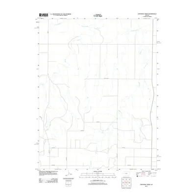
2012 Map of Cheyenne Creek
USGS Topo · Published 2012About this map
The Smoky Hill River meanders across the northern reaches of this High Plains landscape in Lane County, serving as the primary drainage for a network of prairie tributaries. This 2012 survey documents a rural environment defined by its hydrology and a rigid section-line road grid. The central drainage of Cheyenne Cr and the various branches of Salt Creek, including W Salt Cr and E Salt Cr, carve subtle draws into the terrain as they flow toward the river. Transportation in this agricultural area is anchored by named thoroughfares like Lane-Gove Rd and Dodge Rd. The map illustrates the late-20th and early-21st-century rural infrastructure of western Kansas, where most movement follows the precise geometry of county roads like Eagle Rd and N Hickock Rd, contrasting with the fluid, winding paths of the natural waterways.
Find a feature on this map
15 named features on this map. Tap any name to fly to it.
Don’t see what you’re looking for? This feature index may not catch every label — zoom into the map to look around manually.
Map Details
Editions of this 2012 Cheyenne Creek Map
This is the sole edition of this map. No revisions or reprints were ever made.
Other maps of this area

1955 · Scott City
USGS Topo · 1:250,000

1958 · Scott City
USGS Topo · 1:250,000

1974 · Cheyenne Creek
USGS Topo · 1:24,000

1974 · Gove SW
USGS Topo · 1:24,000
1974 · Orion SE
USGS Topo · 1:24,000

1974 · Healy NW
USGS Topo · 1:24,000

1974 · Shields NW
USGS Topo · 1:24,000

1974 · Manning
USGS Topo · 1:24,000

1974 · Healy
USGS Topo · 1:24,000
1974 · Shields
USGS Topo · 1:24,000