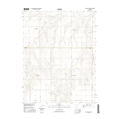
2015 Map of Cheyenne Creek
USGS Topo · Published 2015About this map
The Smoky Hill River carves across the northern reaches of this landscape, marking a significant hydrologic boundary between Gove and Lane counties. This High Plains terrain is defined by its drainage patterns, where Cheyenne Cr and Salt Cr feed into the larger river system, creating a series of draws and ridges across the prairie. The map documents a strictly organized rural section-line road network, anchored by long-stretching thoroughfares like Hickock Rd and Dodge Rd. This grid layout underscores the 19th-century land survey system that partitioned the Kansas territory for settlement and agricultural use. While primary settlements are absent, the density of numbered county roads such as Co Rd 250 and Co Rd 270 suggests a managed landscape of scattered farmsteads and agricultural plots typical of western Kansas in the early 21st century.
Find a feature on this map
20 named features on this map. Tap any name to fly to it.
Don’t see what you’re looking for? This feature index may not catch every label — zoom into the map to look around manually.
Map Details
Editions of this 2015 Cheyenne Creek Map
This is the sole edition of this map. No revisions or reprints were ever made.
Other maps of this area

1955 · Scott City
USGS Topo · 1:250,000

1958 · Scott City
USGS Topo · 1:250,000

1974 · Cheyenne Creek
USGS Topo · 1:24,000

1974 · Gove SW
USGS Topo · 1:24,000
1974 · Orion SE
USGS Topo · 1:24,000

1974 · Healy NW
USGS Topo · 1:24,000

1974 · Shields NW
USGS Topo · 1:24,000

1974 · Manning
USGS Topo · 1:24,000

1974 · Healy
USGS Topo · 1:24,000
1974 · Shields
USGS Topo · 1:24,000