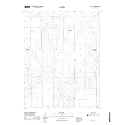
2018 Map of Cheyenne Creek
USGS Topo · Published 2018About this map
The Smoky Hill River flows through the northern reaches of this High Plains landscape, where the boundary of Gove and Lane Counties marks a transition in the western Kansas terrain. The map reveals a drainage system defined by deeply etched seasonal watercourses, including Cheyenne Cr and the various branches of Salt Cr. This area is characterized by a high-density section-line road network, where local routes like Gage Rd and Gove A provide access across a sparsely populated agricultural and ranching environment. The convergence of W Salt Cr and E Salt Cr underscores the importance of these intermittent waterways in an arid region where the river valley and its tributaries dictate the shape of land use and property boundaries.
Find a feature on this map
19 named features on this map. Tap any name to fly to it.
Don’t see what you’re looking for? This feature index may not catch every label — zoom into the map to look around manually.
Map Details
Editions of this 2018 Cheyenne Creek Map
This is the sole edition of this map. No revisions or reprints were ever made.
Other maps of this area

1955 · Scott City
USGS Topo · 1:250,000

1958 · Scott City
USGS Topo · 1:250,000

1974 · Cheyenne Creek
USGS Topo · 1:24,000

1974 · Gove SW
USGS Topo · 1:24,000
1974 · Orion SE
USGS Topo · 1:24,000

1974 · Healy NW
USGS Topo · 1:24,000

1974 · Shields NW
USGS Topo · 1:24,000

1974 · Manning
USGS Topo · 1:24,000

1974 · Healy
USGS Topo · 1:24,000
1974 · Shields
USGS Topo · 1:24,000