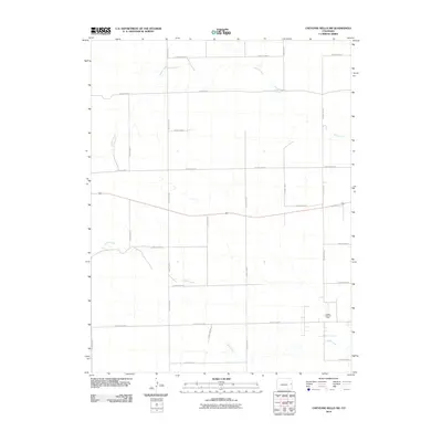
2010 Map of Cheyenne Wells SW
USGS Topo · Published 2010About this map
Willow Creek and Ladder Creek define the drainage of this High Plains landscape in Cheyenne County, providing the only topographic relief across an otherwise strictly rectilinear grid of section lines and county roads. The mapping reveals a sparse, agricultural environment punctuated by modern energy extraction at the Ladder Creek Oil Field in the southeastern portion of the quadrangle. This 2010 survey highlights the intersection of historic land divisions and contemporary resource management, where primary routes like County Road T and County Road R facilitate movement across the open prairie. The layout of the County Road M and surrounding infrastructure reflects the enduring importance of the oil industry to this rural Colorado region at the start of the 21st century.
Find a feature on this map
20 named features on this map. Tap any name to fly to it.
Don’t see what you’re looking for? This feature index may not catch every label — zoom into the map to look around manually.
Map Details
Editions of this 2010 Cheyenne Wells SW Map
This is the sole edition of this map. No revisions or reprints were ever made.
Other maps of this area

1891 · Kit Carson
USGS Topo · 1:125,000

1892 · Cheyenne Wells
USGS Topo · 1:125,000

1893 · Kit Carson
USGS Topo · 1:125,000

1894 · Cheyenne Wells
USGS Topo · 1:125,000

1954 · Lamar
USGS Topo · 1:250,000

1958 · Lamar
USGS Topo · 1:250,000

1981 · Cheyenne Wells
USGS Topo · 1:100,000
1982 · Cheyenne Wells NW
USGS Topo · 1:24,000

1982 · Cheyenne Wells SW
USGS Topo · 1:24,000

1982 · Kit Carson 4 NE
USGS Topo · 1:24,000