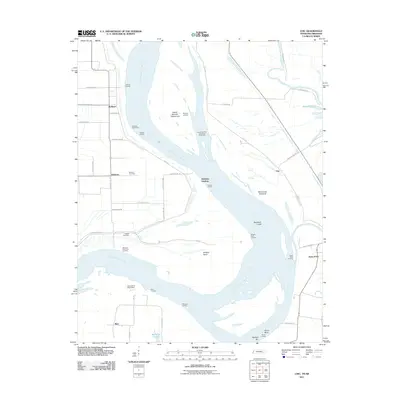
2011 Map of Chic
USGS Topo · Published 2011About this map
The Mississippi River dominates this 2011 survey, defining the border between Tennessee and Arkansas with its complex system of chutes, bars, and revetments. This area is characterized by numerous river-dependent landings, including Hickman Landing, Hales Point Landing, and Huffman Landing, which historically served as vital transport points for the surrounding bottomlands. The landscape is a testament to the river's shifting path, featuring prominent landforms like Island Number Twenty-one, Blue Grass Towhead, and the Needham Cutoff. Inland, the map reveals agricultural patterns serviced by a grid of rural roads such as Levee Rd and Farm Rd. Small settlements like Chic and Hales Point anchor the Tennessee side, while genealogists can locate family burial sites at Buckner Cemetery and Walker Cemetery. The confluence where the Obion River joins the main channel further illustrates the hydrological complexity of the region.
Find a feature on this map
54 named features on this map. Tap any name to fly to it.
Don’t see what you’re looking for? This feature index may not catch every label — zoom into the map to look around manually.
Map Details
Editions of this 2011 Chic Map
This is the sole edition of this map. No revisions or reprints were ever made.
Other maps of this area

1939 · Hales Point
USGS Topo · 1:62,500

1939 · Caruthersville
USGS Topo · 1:62,500

1939 · Blytheville
USGS Topo · 1:62,500

1940 · Hayti
USGS Topo · 1:62,500

1951 · Caruthersville
USGS Topo · 1:62,500

1952 · Hales Point
USGS Topo · 1:62,500

1955 · Hayti
USGS Topo · 1:62,500

1955 · Blytheville
USGS Topo · 1:62,500

1956 · Dyersburg
USGS Topo · 1:250,000

1956 · Blytheville
USGS Topo · 1:250,000