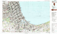
1980 Map of Chicago
USGS Topo · Published 1980About this map
The vast industrial and residential expanse of Chicago and its southern lakeshore suburbs dominate this 1980 study, revealing a complex web of transit and heavy industry at the end of the century's middle decades. The map illustrates the massive scale of the region's transportation infrastructure, from the sprawling Chicago-O'Hare International Airport to the intricate network of the Illinois Central Gulf RR and the Chicago South Shore and South Bend RR. Along the southern curve of Lake Michigan, the industrial landscape of Gary and Hammond is marked by significant maritime features like Burns Waterway Harbor and Buffington Harbor. In contrast to the dense urban grid and major thoroughfares like the Dan Ryan Expressway, the eastern edge of the map preserves the natural shoreline within the Indiana Dunes National Lakeshore, providing a rare look at the original terrain of the Calumet region.
Find a feature on this map
219 named features on this map. Tap any name to fly to it.
Don’t see what you’re looking for? This feature index may not catch every label — zoom into the map to look around manually.
Map Details
Editions of this 1980 Chicago Map
This is the sole edition of this map. No revisions or reprints were ever made.
Other maps of this area

1889 · Chicago
USGS Topo · 1:62,500

1890 · Des Plaines
USGS Topo · 1:62,500

1891 · Chicago
USGS Topo · 1:62,500

1891 · Riverside
USGS Topo · 1:62,500

1892 · Joliet
USGS Topo · 1:62,500

1892 · Calumet
USGS Topo · 1:62,500

1892 · Wilmington
USGS Topo · 1:62,500

1893 · Calumet
USGS Topo · 1:62,500

1893 · Riverside
USGS Topo · 1:62,500

1894 · Des Plaines
USGS Topo · 1:62,500