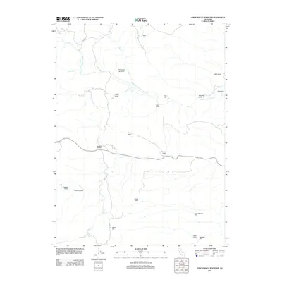
2012 Map of Chickabally Mountain
USGS Topo · Published 2012About this map
Chickabally Mountain rises as the central landmark in this part of Shasta County, where a network of seasonal watercourses and remote flats defines the landscape. The drainage system is anchored by the Middle Fork Cottonwood Cr, which receives flow from numerous named gulches including Rush Gulch, Corral Gulch, and Yuka Gulch. These natural corridors, along with Budden Canyon, indicate a rugged topography shaped by significant elevation changes.
Find a feature on this map
28 named features on this map. Tap any name to fly to it.
Don’t see what you’re looking for? This feature index may not catch every label — zoom into the map to look around manually.
Map Details
Editions of this 2012 Chickabally Mountain Map
This is the sole edition of this map. No revisions or reprints were ever made.
Other maps of this area

1890 · Red Bluff
USGS Topo · 1:250,000

1894 · Red Bluff
USGS Topo · 1:250,000

1949 · Colyear Springs
USGS Topo · 1:62,500

1951 · Chanchelulla Peak
USGS Topo · 1:62,500

1952 · Ono
USGS Topo · 1:62,500

1954 · Yolla Bolly
USGS Topo · 1:62,500

1957 · Colyear Springs
USGS Topo · 1:62,500

1958 · Redding
USGS Topo · 1:250,000
1967 · Cold Fork
USGS Topo · 1:24,000
1967 · Oxbow Bridge
USGS Topo · 1:24,000