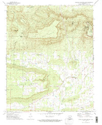
1972 Map of Chickalah Mountain East
USGS Topo · Published 1974About this map
Spring Mountain and the prominent Chickalah Mountain dominate this 1970s landscape, where the high ridges of North Bluff and South Bluff overlook the rural valleys of Yell County. The settlement patterns follow the drainages of Chickalah Creek and Prairie Creek, with small communities like Chickalah and Sulphur Springs serving as local hubs. This era shows a transition in land use, where the protected acreage of the Ozark National Forest and Mount Nebo State Park sits adjacent to active resource extraction, evidenced by several Shale Pits and a Mine near Mc Cray Ridge. Genealogists will find significant value in the documentation of family and community landmarks, including Mountain Spring Cem and the Chickalah Mountain Ch, which anchor these upland neighborhoods before modern development altered the rural fabric of the region.
Find a feature on this map
54 named features on this map. Tap any name to fly to it.
Don’t see what you’re looking for? This feature index may not catch every label — zoom into the map to look around manually.
Map Details
Editions of this 1972 Chickalah Mountain East Map
2 editions found
Other maps of this area

1888 · Dardanelle #4
USGS Topo · 1:62,500

1888 · Dardanelle #2
USGS Topo · 1:62,500

1888 · Dardanelle #1
USGS Topo · 1:62,500

1888 · Dardanelle #3
USGS Topo · 1:62,500

1890 · Dardanelle
USGS Topo · 1:125,000

1956 · Russellville
USGS Topo · 1:250,000
1962 · New Blaine
USGS Topo · 1:24,000

1962 · Delaware
USGS Topo · 1:24,000
1963 · Russellville West
USGS Topo · 1:24,000

1964 · Russellville
USGS Topo · 1:250,000