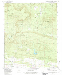
1972 Map of Chickalah Mountain West
USGS Topo · Published 1982About this map
Huckleberry Mountain and Chickalah Mountain dominate the topography of this Yell County region, which is largely encompassed by the Ozark National Forest. The landscape is defined by its deep hollows and high ridges, including North Bluff and South Bluff, where early settlers established small communities and rural family homesteads. The map captures a high density of local genealogical interest, with numerous small burial grounds such as Utley Cem, Harkey Cem, and Stafford Cem scattered throughout the valleys.
Find a feature on this map
57 named features on this map. Tap any name to fly to it.
Don’t see what you’re looking for? This feature index may not catch every label — zoom into the map to look around manually.
Map Details
Editions of this 1972 Chickalah Mountain West Map
2 editions found
Other maps of this area

1879 · Mountain Home
USGS Topo · 1:62,500

1887 · Magazine Mountain #1
USGS Topo · 1:62,500

1887 · Magazine Mountain #4
USGS Topo · 1:62,500

1887 · Magazine Mountain
USGS Topo · 1:62,500

1888 · Dardanelle #2
USGS Topo · 1:62,500

1888 · Dardanelle #3
USGS Topo · 1:62,500

1890 · Magazine Mountain
USGS Topo · 1:125,000

1890 · Dardanelle
USGS Topo · 1:125,000

1956 · Russellville
USGS Topo · 1:250,000
1961 · Scranton
USGS Topo · 1:24,000