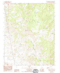
1986 Map of Chickencoop Canyon
USGS Topo · Published 1994About this map
Yokohl Valley and the surrounding drainage basins of the Sierra Nevada foothills define this terrain during the mid-1980s. The landscape is characterized by its complex network of canyons and upland flats, including Chickencoop Canyon, Paradise Canyon, and Jordan Flat. Evidence of human activity is scattered across the topography, ranging from the solitary Hinds Cabin to multiple prospect sites, reflecting a history of small-scale exploration and seasonal ranching or habitation. The water system is particularly detailed, tracing the courses of Yokohl Creek, Horse Creek, and Van Gordon Creek as they navigate the ridges and depressions. A single Radio Tower stands as a modern landmark on the heights, while older place names like Potato Hill and Little Oak Flat ground the map in its local geographic identity. This survey serves as a vital record of the Tulare County backcountry before subsequent shifts in land use or environmental change.
Find a feature on this map
20 named features on this map. Tap any name to fly to it.
Don’t see what you’re looking for? This feature index may not catch every label — zoom into the map to look around manually.
Map Details
Editions of this 1986 Chickencoop Canyon Map
2 editions found
Other maps of this area

1904 · Kaweah
USGS Topo · 1:125,000

1909 · Kaweah
USGS Topo · 1:125,000

1925 · Rocky Hill
USGS Topo · 1:31,680

1927 · Rocky Hill
USGS Topo · 1:31,680

1928 · Lemon Cove
USGS Topo · 1:31,680

1928 · Lindsay
USGS Topo · 1:31,680

1937 · Kaweah
USGS Topo · 1:125,000
1942 · Porterville
USGS Topo · 1:62,500

1948 · Fresno
USGS Topo · 1:250,000
1951 · Rocky Hill
USGS Topo · 1:24,000