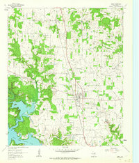
1961 Map of Chico
USGS Topo · Published 1964About this map
The town of Chico serves as the industrial and transport anchor for this North Texas region during the early 1960s. The landscape is defined by the extensive Miles Jackson Oil Field and the surrounding infrastructure of the petroleum and mineral industries, including a Gasoline Refinery and several Quarry sites. The Chicago Rock Island and Pacific railroad bisects the area, with specialized branches like the Lone Star Spur and an unnamed spur serving the local quarries. In the southwest, the waters of Lake Bridgeport meet the West Fork Trinity River, with shoreline areas marked for controlled inundation. Local history is anchored by rural landmarks such as Red Bud Ch, Cumby Cem, and Olive Branch Cem, while the Bridgeport Airfield and a nearby Airway Beacon reflect mid-century aviation needs.
Find a feature on this map
22 named features on this map. Tap any name to fly to it.
Don’t see what you’re looking for? This feature index may not catch every label — zoom into the map to look around manually.
Map Details
Editions of this 1961 Chico Map
2 editions found
Other maps of this area

1930 · Boyd
USGS Topo · 1:62,500

1954 · Sherman
USGS Topo · 1:250,000

1958 · Sherman
USGS Topo · 1:250,000

1960 · Bridgeport West
USGS Topo · 1:24,000

1960 · Bridgeport East
USGS Topo · 1:24,000

1960 · Wizard Wells
USGS Topo · 1:24,000

1961 · Selma
USGS Topo · 1:24,000

1961 · Alvord
USGS Topo · 1:24,000

1961 · Sunset
USGS Topo · 1:24,000
1961 · Smyrna
USGS Topo · 1:24,000