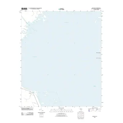
2011 Map of Chicora
USGS Topo · Published 2011About this map
Lake Moultrie dominates this corner of Berkeley County, its expansive surface area defining the local geography and recreational landscape. Along its eastern shore, the settlement of Bonneau Beach serves as a primary access point to the water, while the southwestern corner features the small community of Chicora. This area is characterized by the engineered structures of the Santee Cooper project, including the West Dike and the Diversion Canal in the northwest, which connect the basin's water systems. Land-based navigation relies on local corridors such as Halls Rd and Blacks Camp Rd, which weave through the finger-like peninsulas and marshy inlets along the lake's edge. The presence of White Point Beach further underscores the shoreline's role as a focus for local activity and topography during this era.
Find a feature on this map
10 named features on this map. Tap any name to fly to it.
Don’t see what you’re looking for? This feature index may not catch every label — zoom into the map to look around manually.
Map Details
Editions of this 2011 Chicora Map
This is the sole edition of this map. No revisions or reprints were ever made.
Other maps of this area

1919 · Summerville
USGS Topo · 1:48,000

1919 · Cordesville
USGS Topo · 1:48,000

1920 · Chicora
USGS Topo · 1:48,000

1920 · Summerville
USGS Topo · 1:62,500

1921 · Chicora
USGS Topo · 1:62,500

1943 · Chicora
USGS Topo · 1:62,500

1943 · Bonneau
USGS Topo · 1:62,500

1944 · Summerville
USGS Topo · 1:62,500

1948 · Cordesville
USGS Topo · 1:24,000
1949 · Cordesville
USGS Topo · 1:24,000