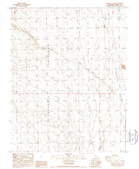
1987 Map of Chidago Canyon
USGS Topo · Published 1987About this map
The Volcanic Tableland dominates the western half of this terrain, showing a complex network of drainage channels and elevation markers that reveal the prehistoric geologic activity of the Owens Valley region. The map transitions eastward into the distinct basins of Hammil Valley and Chalfant Valley, separated by rising ridges and the cut of Chidago Canyon. This 1987 provisional survey identifies scattered human footprints in the arid landscape, including isolated Gravel Pits, a small Mine, and unnamed Ruins situated near the eastern valley floor. Water sources are rare but specifically noted at Fish Slough in the south and along Milner Cr to the northeast, where the valley floor supports sparse development compared to the high, broken tablelands. The contrast between the flat valley troughs and the deeply incised volcanic plateau highlights the varied geomorphology of Mono County.
Find a feature on this map
14 named features on this map. Tap any name to fly to it.
Don’t see what you’re looking for? This feature index may not catch every label — zoom into the map to look around manually.
Map Details
Editions of this 1987 Chidago Canyon Map
This is the sole edition of this map. No revisions or reprints were ever made.
Other maps of this area

1912 · Mt. Goddard
USGS Topo · 1:125,000

1913 · Bishop
USGS Topo · 1:125,000

1914 · Mt. Morrison
USGS Topo · 1:125,000

1917 · White Mountain
USGS Topo · 1:125,000

1947 · Mariposa
USGS Topo · 1:250,000

1948 · Mariposa
USGS Topo · 1:250,000

1949 · Mt. Tom
USGS Topo · 1:62,500

1949 · Bishop
USGS Topo · 1:62,500

1951 · Mt. Tom
USGS Topo · 1:62,500

1951 · Bishop
USGS Topo · 1:62,500