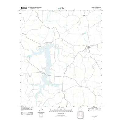
2011 Map of Chidester
USGS Topo · Published 2011About this map
White Oak Lake State Park anchors this landscape in western Arkansas, where the bifurcated waters of Lower White Oak Lake and Upper White Oak Lake dominate the terrain. The town of Chidester serves as the primary local hub, positioned at a crossroads near the Barham Branch and Beavers Lake. The area's rural character is defined by a network of drainage systems like Panther Branch and Bragg Mill Creek that feed into the larger reservoirs.
Find a feature on this map
73 named features on this map. Tap any name to fly to it.
Don’t see what you’re looking for? This feature index may not catch every label — zoom into the map to look around manually.
Map Details
Editions of this 2011 Chidester Map
This is the sole edition of this map. No revisions or reprints were ever made.
Other maps of this area

1901 · Gurdon
USGS Topo · 1:125,000

1903 · Camden
USGS Topo · 1:125,000

1953 · El Dorado
USGS Topo · 1:250,000

1957 · El Dorado
USGS Topo · 1:250,000

1958 · El Dorado
USGS Topo · 1:250,000

1960 · El Dorado
USGS Topo · 1:250,000

1970 · Whelen Springs
USGS Topo · 1:24,000

1970 · Reader
USGS Topo · 1:24,000

1971 · Tates Bluff
USGS Topo · 1:24,000
1971 · Bragg City
USGS Topo · 1:24,000