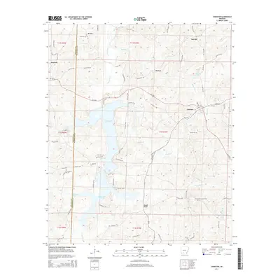
2014 Map of Chidester
USGS Topo · Published 2014About this map
Chidester and the surrounding timberlands of Ouachita and Nevada counties are defined by a complex network of creeks and managed wetlands. The landscape is dominated by the expansive Lower White Oak Lake and Upper White Oak Lake, which together form a significant waterway system fed by White Oak Cr and Panther Br. Small rural communities like Reader and Good Hope are connected by a web of state highways and county roads, including the prominent AR 24 Hwy corridor. Local history is deeply etched into the land through numerous small burial grounds such as Purifoy Cem and Holleman Cem. The presence of the Poison Springs Lookout Tower reflects the region's historical reliance on forestry management, while settlements like Bluff City and Barham mark the intersections of these rural transport routes.
Find a feature on this map
86 named features on this map. Tap any name to fly to it.
Don’t see what you’re looking for? This feature index may not catch every label — zoom into the map to look around manually.
Map Details
Editions of this 2014 Chidester Map
This is the sole edition of this map. No revisions or reprints were ever made.
Other maps of this area

1901 · Gurdon
USGS Topo · 1:125,000

1903 · Camden
USGS Topo · 1:125,000

1953 · El Dorado
USGS Topo · 1:250,000

1957 · El Dorado
USGS Topo · 1:250,000

1958 · El Dorado
USGS Topo · 1:250,000

1960 · El Dorado
USGS Topo · 1:250,000

1970 · Whelen Springs
USGS Topo · 1:24,000

1970 · Reader
USGS Topo · 1:24,000

1971 · Tates Bluff
USGS Topo · 1:24,000
1971 · Bragg City
USGS Topo · 1:24,000