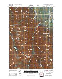
2011 Map of Chief Joseph Mountain
USGS Topo · Published 2011About this map
Chief Joseph Mountain and the high ridges of the Wallowa range dominate this 2011 landscape, where alpine peaks descend into the agricultural valley surrounding Joseph. The map reveals a complex water management system essential to the high desert, including the Silver Grange Ditch, Hurricane Ditch, and Consolidated Ditch, which divert mountain runoff from Hurricane Creek to the valley floor. High-altitude landmarks like the Legore Mine and the Miners Basin point to a history of resource extraction above the timberline, while the Hurricane Grange serves as a reminder of the area's deep-rooted farming community.
Find a feature on this map
56 named features on this map. Tap any name to fly to it.
Don’t see what you’re looking for? This feature index may not catch every label — zoom into the map to look around manually.
Map Details
Editions of this 2011 Chief Joseph Mountain Map
This is the sole edition of this map. No revisions or reprints were ever made.
Other maps of this area

1954 · Cornucopia
USGS Topo · 1:62,500

1954 · Eagle Cap
USGS Topo · 1:62,500

1955 · Grangeville
USGS Topo · 1:250,000

1957 · Enterprise
USGS Topo · 1:62,500

1957 · Joseph
USGS Topo · 1:62,500

1959 · Grangeville
USGS Topo · 1:250,000

1986 · Enterprise
USGS Topo · 1:100,000

1990 · Lostine
USGS Topo · 1:24,000

1990 · Chief Joseph Mtn
USGS Topo · 1:24,000
1990 · Eagle Cap
USGS Topo · 1:24,000