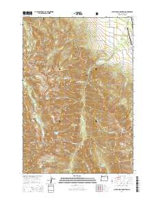
2014 Map of Chief Joseph Mountain
USGS Topo · Published 2014About this map
Chief Joseph Mountain stands as the dramatic centerpiece of this high-altitude landscape in the Wallowa National Forest. The map documents a sharp transition from the irrigated ranching lands of Alder Slope to the alpine wilderness of the Wallowa Range. Water management is a primary feature of the lowlands, where the Hurricane Ditch and Silver Grange Ditch divert mountain runoff to support the valley floor. To the southwest, the terrain climbs toward sharp ridges and glacial basins, including Sawtooth Peak and Traverse Ridge. High-altitude water bodies such as Legore Lake, Francis Lake, and Echo Lake dot the granite landscape, while named features like Miners Basin hint at the area's legacy of mountain exploration. The presence of the Joseph State Airport and Joseph Cem at the northeastern edge marks the boundary between the wilderness and the edge of the community.
Find a feature on this map
55 named features on this map. Tap any name to fly to it.
Don’t see what you’re looking for? This feature index may not catch every label — zoom into the map to look around manually.
Map Details
Editions of this 2014 Chief Joseph Mountain Map
This is the sole edition of this map. No revisions or reprints were ever made.
Other maps of this area

1954 · Cornucopia
USGS Topo · 1:62,500

1954 · Eagle Cap
USGS Topo · 1:62,500

1955 · Grangeville
USGS Topo · 1:250,000

1957 · Enterprise
USGS Topo · 1:62,500

1957 · Joseph
USGS Topo · 1:62,500

1959 · Grangeville
USGS Topo · 1:250,000

1986 · Enterprise
USGS Topo · 1:100,000

1990 · Lostine
USGS Topo · 1:24,000

1990 · Chief Joseph Mtn
USGS Topo · 1:24,000
1990 · Eagle Cap
USGS Topo · 1:24,000