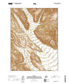
2020 Map of Chignik A-4 SE
USGS Topo · Published 2020About this map
The northern reaches of the Aleutian Range dominate this landscape, where steep, high-elevation terrain gives way to deep glacial valleys. The drainage system is defined by Red Bluff Cr, which cuts through the southern portion of the quadrangle, carrying runoff from the surrounding peaks toward the coast. This 2020 map documents a remote stretch of the Alaska Peninsula, emphasizing the natural topography rather than human settlement. The absence of roads or structures highlights the wilderness character of the region, where land management is delineated by the Public Land Survey System grids of t47s r63w and t48s r63w. For the researcher or traveler, the map provides a precise record of the vertical relief and the specific watercourses that shape this part of the Lake and Peninsula Borough.
Find a feature on this map
6 named features on this map. Tap any name to fly to it.
Don’t see what you’re looking for? This feature index may not catch every label — zoom into the map to look around manually.
Map Details
Editions of this 2020 Chignik A-4 SE Map
This is the sole edition of this map. No revisions or reprints were ever made.
Other maps of this area

1951 · Stepovak Bay
USGS Topo · 1:250,000

1963 · Chignik A-4
USGS Topo · 1:63,360

1963 · Stepovak Bay D-4
USGS Topo · 1:63,360

1963 · Chignik A-3
USGS Topo · 1:63,360

1963 · Chignik
USGS Topo · 1:250,000
1963 · Stepovak Bay D-3
USGS Topo · 1:63,360

1963 · Stepovak Bay
USGS Topo · 1:250,000

1969 · Stepovak Bay
USGS Topo · 1:250,000
2020 · Stepovak Bay D-4 NW
USGS Topo · 1:25,000
2020 · Stepovak Bay D-4 NE
USGS Topo · 1:25,000