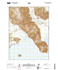
2020 Map of Stepovak Bay D-4 NE
USGS Topo · Published 2020About this map
Perryville sits on the southern coast of the Alaska Peninsula, where the Kametolook River meets the Gulf of Alaska. The settlement's layout reflects a modern infrastructure adapted to the landscape, featuring the Perryville Airport and a small network of local connectors like Brooks Road and Landfill Road. Genealogists and local historians will find the Perryville Village Graveyard noted near the coast, providing a specific anchor for family research in this Alutiiq community. To the east, the terrain rises sharply toward Red Bluff Mtn, which overlooks the waters of Anchor Bay and the prominent headland at Coal Cape. This map illustrates the intersection of a remote coastal village with its surrounding wilderness, from the offshore Shapka Island to the drainage of Red Bluff Cr.
Find a feature on this map
19 named features on this map. Tap any name to fly to it.
Don’t see what you’re looking for? This feature index may not catch every label — zoom into the map to look around manually.
Map Details
Editions of this 2020 Stepovak Bay D-4 NE Map
This is the sole edition of this map. No revisions or reprints were ever made.
Other maps of this area

1951 · Stepovak Bay
USGS Topo · 1:250,000

1963 · Chignik A-4
USGS Topo · 1:63,360

1963 · Stepovak Bay D-4
USGS Topo · 1:63,360

1963 · Chignik A-3
USGS Topo · 1:63,360

1963 · Chignik
USGS Topo · 1:250,000
1963 · Stepovak Bay D-3
USGS Topo · 1:63,360

1963 · Stepovak Bay
USGS Topo · 1:250,000

1969 · Stepovak Bay
USGS Topo · 1:250,000
2020 · Stepovak Bay D-4 NW
USGS Topo · 1:25,000
2020 · Chignik A-3 SW
USGS Topo · 1:25,000