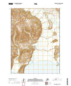
2020 Map of Stepovak Bay D-4 NW
USGS Topo · Published 2020About this map
The Alaska Peninsula is defined here by the steep, glaciated terrain of the Aleutian Range, where high mountain ridges descend sharply toward the southern coastline. This 2020 U.S. Geological Survey topographic map captures the drainage patterns of the Kametolook River as it flows south through the townships of t48s r64w and t49s r64w. The landscape transition is stark, moving from high-elevation peaks down to the coastal threshold at Three Star Point, which marks a distinct protrusion into the cold waters of Stepovak Bay. The lack of modern infrastructure highlights the enduring isolation of this part of the Lake and Peninsula Borough, where the public land survey system remains the primary method for defining the vast tracts of wilderness.
Find a feature on this map
10 named features on this map. Tap any name to fly to it.
Don’t see what you’re looking for? This feature index may not catch every label — zoom into the map to look around manually.
Map Details
Editions of this 2020 Stepovak Bay D-4 NW Map
This is the sole edition of this map. No revisions or reprints were ever made.
Other maps of this area

1951 · Stepovak Bay
USGS Topo · 1:250,000

1963 · Chignik A-4
USGS Topo · 1:63,360

1963 · Stepovak Bay D-4
USGS Topo · 1:63,360

1963 · Chignik A-5
USGS Topo · 1:63,360

1963 · Stepovak Bay D-5
USGS Topo · 1:63,360

1963 · Chignik
USGS Topo · 1:250,000

1963 · Stepovak Bay
USGS Topo · 1:250,000

1969 · Stepovak Bay
USGS Topo · 1:250,000
2020 · Stepovak Bay D-4 NE
USGS Topo · 1:25,000
2020 · Stepovak Bay D-5 NE
USGS Topo · 1:25,000