
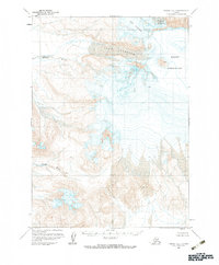
1963 Map of Chignik A-5
USGS Topo · Published 1967About this map
Mount Veniaminof dominates this Alaskan landscape, captured during a 1963 field annotation. The massive volcano's summit is marked by a prominent Crater, surrounded by an extensive network of ice and geological activity. Glacial movement is central to the area's geography, with the Cone Glacier, Fog Glacier, and Island Glacier carving through the high elevations. The presence of Crevasses and fields of Lava emphasize the volatile, ever-changing nature of this volcanic terrain.
Find a feature on this map
9 named features on this map. Tap any name to fly to it.
Don’t see what you’re looking for? This feature index may not catch every label — zoom into the map to look around manually.
Map Details
Editions of this 1963 Chignik A-5 Map
2 editions found
Other maps of this area

1951 · Stepovak Bay
USGS Topo · 1:250,000

1963 · Chignik A-4
USGS Topo · 1:63,360

1963 · Stepovak Bay D-4
USGS Topo · 1:63,360

1963 · Chignik A-6
USGS Topo · 1:63,360

1963 · Chignik B-5
USGS Topo · 1:63,360

1963 · Chignik B-4
USGS Topo · 1:63,360

1963 · Chignik B-6
USGS Topo · 1:63,360

1963 · Stepovak Bay D-6
USGS Topo · 1:63,360

1963 · Stepovak Bay D-5
USGS Topo · 1:63,360

1963 · Chignik
USGS Topo · 1:250,000