
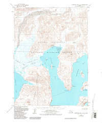
1963 Map of Stepovak Bay D-5
USGS Topo · Published 1968About this map
Ivanof Bay and the adjacent Humpback Bay dominate this remote coastal landscape along the Kupreanof Peninsula. The 1963 survey captures the maritime infrastructure of the era, centered around a Cannery and its associated Seaplane Anchorage on the northern shore of Ivanof Bay. This region is defined by complex shorelines where the Ivanof River and Humpback Creek meet the sea, creating vast Tidal Flats and Stepanof Flats. To the west, the Granville Portage cuts through the lowlands of Smoky Hollow, providing a historical transit route toward Stepovak Bay. Scattered Cabins near Kupreanof Harbor and on James Island suggest the seasonal nature of fishing and trapping life in the mid-20th century before significant modern development altered these remote outposts.
Find a feature on this map
41 named features on this map. Tap any name to fly to it.
Don’t see what you’re looking for? This feature index may not catch every label — zoom into the map to look around manually.
Map Details
Editions of this 1963 Stepovak Bay D-5 Map
2 editions found
Other maps of this area

1951 · Stepovak Bay
USGS Topo · 1:250,000

1963 · Chignik A-4
USGS Topo · 1:63,360
1963 · Stepovak Bay C-5 and C-6
USGS Topo · 1:63,360

1963 · Stepovak Bay D-4
USGS Topo · 1:63,360

1963 · Chignik A-6
USGS Topo · 1:63,360

1963 · Chignik A-5
USGS Topo · 1:63,360

1963 · Stepovak Bay D-6
USGS Topo · 1:63,360

1963 · Chignik
USGS Topo · 1:250,000

1963 · Stepovak Bay
USGS Topo · 1:250,000

1969 · Stepovak Bay
USGS Topo · 1:250,000