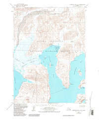
1963 Map of Stepovak Bay D-5
USGS Topo · Published 1984About this map
Ivanof Bay serves as a primary coastal anchor in this mid-century portrait of the Alaska Peninsula, where the local economy and maritime activity are centered around the Cannery and several clusters of cabins. The landscape is a complex network of glacial and tidal features, notably the Stepanof Flats and Smoky Hollow which lead toward the Granville Portage. The map details the transition from the sheltered waters of Ivanof Bay to the open reaches of Stepovak Bay and Humpback Bay. Small islands such as James Island, Road Island, and Egg Island dot the coastline, while a cemetery near the main settlement provides a specific point of interest for genealogists tracing maritime families in this isolated region. This area, largely encompassed by the Alaska Peninsula National Wildlife Refuge, remains defined by its lack of roads and its reliance on waterways like the Ivanof River and Osterback Creek.
Find a feature on this map
25 named features on this map. Tap any name to fly to it.
Don’t see what you’re looking for? This feature index may not catch every label — zoom into the map to look around manually.
Map Details
Editions of this 1963 Stepovak Bay D-5 Map
2 editions found
Other maps of this area

1951 · Stepovak Bay
USGS Topo · 1:250,000

1963 · Chignik A-4
USGS Topo · 1:63,360
1963 · Stepovak Bay C-5 and C-6
USGS Topo · 1:63,360

1963 · Stepovak Bay D-4
USGS Topo · 1:63,360

1963 · Chignik A-6
USGS Topo · 1:63,360

1963 · Chignik A-5
USGS Topo · 1:63,360

1963 · Stepovak Bay D-6
USGS Topo · 1:63,360

1963 · Stepovak Bay D-5
USGS Topo · 1:63,360

1963 · Chignik
USGS Topo · 1:250,000

1963 · Stepovak Bay
USGS Topo · 1:250,000