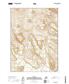
2020 Map of Chignik A-4 SW
USGS Topo · Published 2020About this map
The Aleutian Range dominates this landscape in the Lake and Peninsula Borough of Alaska, as documented in this 2020 topographic survey. The terrain is defined by dramatic elevation changes and significant glacial coverage, particularly in the northern sections. Waterways like Red Bluff Cr in the northeast and the Kametolook River in the southwest carve through the high-altitude topography, illustrating the drainage patterns of this Alaskan peninsula region. Surveyed according to the Public Land Survey System, the area includes portions of t47s r64w and t48s r63w, highlighting the underlying administrative grid imposed on this undeveloped coastal wilderness. The contrast between the expansive ice fields and the deeply incised river valleys provides a clear view of the geologic forces shaping the peninsula.
Find a feature on this map
7 named features on this map. Tap any name to fly to it.
Don’t see what you’re looking for? This feature index may not catch every label — zoom into the map to look around manually.
Map Details
Editions of this 2020 Chignik A-4 SW Map
This is the sole edition of this map. No revisions or reprints were ever made.
Other maps of this area

1951 · Stepovak Bay
USGS Topo · 1:250,000

1963 · Chignik A-4
USGS Topo · 1:63,360

1963 · Stepovak Bay D-4
USGS Topo · 1:63,360

1963 · Chignik A-5
USGS Topo · 1:63,360

1963 · Stepovak Bay D-5
USGS Topo · 1:63,360

1963 · Chignik
USGS Topo · 1:250,000

1963 · Stepovak Bay
USGS Topo · 1:250,000

1969 · Stepovak Bay
USGS Topo · 1:250,000
2020 · Stepovak Bay D-4 NW
USGS Topo · 1:25,000
2020 · Stepovak Bay D-4 NE
USGS Topo · 1:25,000