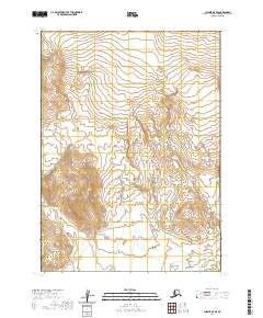
2020 Map of Chignik A-5 SE
USGS Topo · Published 2020About this map
The Aleutian Range dominates this portion of the Alaska Peninsula, where steep topographic gradients define a wilderness largely untouched by development. The Kametolook River is the primary drainage feature, winding through the valley floor and carving a path through the peaks. This 2020 survey demonstrates the raw, glacial-sculpted character of the region, emphasizing the isolation of the high ridges within the Lake and Peninsula Borough. The absence of roads or settlements highlights the environmental severity of the peninsula, where the landscape is governed strictly by the water systems and the volcanic geography of the range. Maps like this are essential for understanding the unmodified hydrology of the Alaskan backcountry before modern climate shifts further alter the terrain.
Find a feature on this map
8 named features on this map. Tap any name to fly to it.
Don’t see what you’re looking for? This feature index may not catch every label — zoom into the map to look around manually.
Map Details
Editions of this 2020 Chignik A-5 SE Map
This is the sole edition of this map. No revisions or reprints were ever made.
Other maps of this area

1951 · Stepovak Bay
USGS Topo · 1:250,000

1963 · Chignik A-4
USGS Topo · 1:63,360

1963 · Stepovak Bay D-4
USGS Topo · 1:63,360

1963 · Chignik A-5
USGS Topo · 1:63,360

1963 · Stepovak Bay D-5
USGS Topo · 1:63,360

1963 · Chignik
USGS Topo · 1:250,000

1963 · Stepovak Bay
USGS Topo · 1:250,000

1969 · Stepovak Bay
USGS Topo · 1:250,000
2020 · Stepovak Bay D-4 NW
USGS Topo · 1:25,000
2020 · Stepovak Bay D-5 NE
USGS Topo · 1:25,000