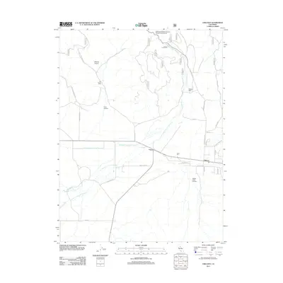
2012 Map of Chilcoot
USGS Topo · Published 2012About this map
Vinton and Chilcoot serve as the primary hubs in this high-altitude valley of Plumas County, situated along a network of ranching roads and water channels. The landscape is defined by the braided path of Little Last Chance Cr, which branches into north and east channels near the settlements. To the north, the Little Last Chance Canyon Special Interest Area and Chilcoot Campground mark the transition into more mountainous terrain, where Whiskey Canyon and Trosi Canyon cut through the upland. Local family history and land use are etched into the map through features like the Trosi Canyon Ranch, Vinton Cem, and several named roads such as Ramelli-Greig Rd and Dotta Guidici Rd. The presence of Dyson Slough and Adams Neck further highlights the unique drainage and topographical features that have shaped the agricultural and transit patterns of this Sierra Nevada region.
Find a feature on this map
40 named features on this map. Tap any name to fly to it.
Don’t see what you’re looking for? This feature index may not catch every label — zoom into the map to look around manually.
Map Details
Editions of this 2012 Chilcoot Map
This is the sole edition of this map. No revisions or reprints were ever made.
Other maps of this area

1890 · Sierraville
USGS Topo · 1:125,000

1892 · Sierraville
USGS Topo · 1:125,000

1894 · Sierraville
USGS Topo · 1:125,000

1950 · Chilcoot
USGS Topo · 1:62,500

1950 · Portola
USGS Topo · 1:62,500

1955 · Loyalton
USGS Topo · 1:62,500

1955 · Sierraville
USGS Topo · 1:62,500

1958 · Chico
USGS Topo · 1:250,000

1960 · Chico
USGS Topo · 1:250,000
1972 · Reconnaissance Peak
USGS Topo · 1:24,000