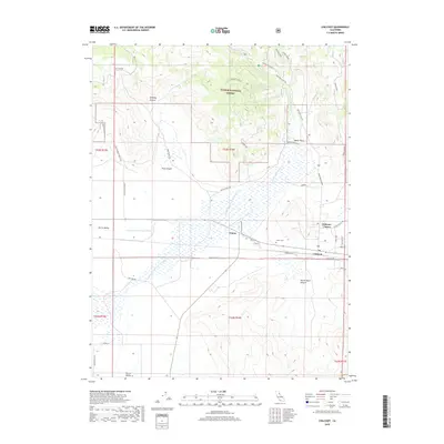
2018 Map of Chilcoot
USGS Topo · Published 2018About this map
Sierra Valley opens up in this High Sierra landscape where the high desert meets the northern mountains. The small settlements of Vinton, Chilcoot, and the combined Chilcoot-Venton area serve as the primary hubs of activity along the southern edge of the Plumas National Forest. Water management is a defining characteristic of this terrain, visible through the complex drainage of the N Channel Little Last Chance Cr and E Channel Little Last Chance Cr as they navigate the flat valley floor. The map highlights the transition from the rugged slopes of Chilcoot Heights and Trosi Canyon to the cultivated lands and ranch roads like Harrison Ranch Rd and Dotta Guidici Rd. For local historians, the Vinton Cem provides a specific point of genealogical interest near the community center.
Find a feature on this map
38 named features on this map. Tap any name to fly to it.
Don’t see what you’re looking for? This feature index may not catch every label — zoom into the map to look around manually.
Map Details
Editions of this 2018 Chilcoot Map
This is the sole edition of this map. No revisions or reprints were ever made.
Other maps of this area

1890 · Sierraville
USGS Topo · 1:125,000

1892 · Sierraville
USGS Topo · 1:125,000

1894 · Sierraville
USGS Topo · 1:125,000

1950 · Chilcoot
USGS Topo · 1:62,500

1950 · Portola
USGS Topo · 1:62,500

1955 · Loyalton
USGS Topo · 1:62,500

1955 · Sierraville
USGS Topo · 1:62,500

1958 · Chico
USGS Topo · 1:250,000

1960 · Chico
USGS Topo · 1:250,000
1972 · Reconnaissance Peak
USGS Topo · 1:24,000