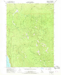
1966 Map of Childs Hill
USGS Topo · Published 1968About this map
The Pacific Ocean meets the coastline of Northern California in this mid-1960s study, where the steep, timbered ridges of the Six Rivers National Forest dominate the interior. The landscape is defined by the drainage basins of Mill Creek and its many tributaries, including the East Fork and West Branch. These waters carve through the terrain beneath Childs Hill and Bald Hill, creating a complex network of canyons that historically slowed development in the region. Along the western edge, the Del Norte Coast Redwoods State Park protects a significant corridor of the coastal forest. The lack of major settlements and the reliance on a Jeep Trail or the Hamilton Road for access underscores the region's character as a resource-rich wilderness. Researchers can trace the varied terrain from Bummer Lake down to the rocky coastline near Nickel Creek.
Find a feature on this map
18 named features on this map. Tap any name to fly to it.
Don’t see what you’re looking for? This feature index may not catch every label — zoom into the map to look around manually.
Map Details
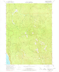
Editions of this 1966 Childs Hill Map
4 editions found
Other maps of this area

1922 · Preston Peak
USGS Topo · 1:125,000

1929 · Crescent City
USGS Topo · 1:125,000

1945 · Ship Mountain
USGS Topo · 1:62,500

1945 · Gasquet
USGS Topo · 1:62,500

1945 · Point St. George
USGS Topo · 1:62,500

1945 · Requa
USGS Topo · 1:62,500

1948 · Weed
USGS Topo · 1:250,000

1949 · Eureka
USGS Topo · 1:250,000

1950 · Weed
USGS Topo · 1:250,000

1951 · Gasquet
USGS Topo · 1:62,500