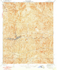
1942 Map of Chileno Canyon
USGS Topo · Published 1948About this map
The West Fork San Gabriel River cuts a deep course through the heart of the San Gabriel Mountains in this 1940s landscape, which was revised just after the war by the Los Angeles County Engineer. The geography is dominated by water management and mountain access, featuring Dam No 2 and the West Reservoir as critical pieces of regional flood control. Human presence is marked by isolated structures such as the Pasadena Bait Club and remote outposts like Stone Cabin and Tool Cabin. Higher elevations are defined by the winding Angeles Crest Highway and several designated firebreaks. From the heights of Monrovia Peak to the canyon floor at Spring Camp, the map documents the infrastructure required to manage these steep watersheds before mid-century development further altered the drainage patterns of the Angeles National Forest.
Find a feature on this map
33 named features on this map. Tap any name to fly to it.
Don’t see what you’re looking for? This feature index may not catch every label — zoom into the map to look around manually.
Map Details
Editions of this 1942 Chileno Canyon Map
4 editions found
Other maps of this area

1894 · Los Angeles
USGS Topo · 1:62,500

1894 · Pomona
USGS Topo · 1:62,500

1896 · Pasadena
USGS Topo · 1:62,500

1897 · Pomona
USGS Topo · 1:62,500

1898 · Pomona
USGS Topo · 1:62,500

1900 · Pasadena
USGS Topo · 1:62,500

1900 · Tujunga
USGS Topo · 1:62,500

1900 · Los Angeles
USGS Topo · 1:62,500

1901 · Southern California Sheet No. 1
USGS Topo · 1:250,000

1903 · Rock Creek
USGS Topo · 1:62,500