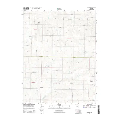
2014 Map of Chilhowee
USGS Topo · Published 2014About this map
The agrarian landscape of West-Central Missouri is meticulously documented in this survey, defined by the border between Johnson and Henry counties. The area is anchored by the dual presence of Old Chilhowee and the primary settlement of Chilhowee, showing the evolution of local centers over time. This region is characterized by its drainage network, where the headwaters of Hogan Fork and E Fork Post Oak Cr carve through the agricultural uplands. Significant for genealogists, the map identifies local burial sites such as Providence Cemetery to the northeast and Carrsville Cemetery near Petersburg in the south. The transition from the rural roads of Johnson County to the northern reaches of Henry County reveals a pattern of dispersed settlements including Post Oak and the landmark Shawnee Mound, illustrating the sparse but deliberate distribution of early Missouri communities.
Find a feature on this map
57 named features on this map. Tap any name to fly to it.
Don’t see what you’re looking for? This feature index may not catch every label — zoom into the map to look around manually.
Map Details
Editions of this 2014 Chilhowee Map
This is the sole edition of this map. No revisions or reprints were ever made.
Other maps of this area

1885 · Warrensburg
USGS Topo · 1:125,000

1887 · Clinton
USGS Topo · 1:125,000

1887 · Warrensburg
USGS Topo · 1:125,000

1894 · Warrensburg
USGS Topo · 1:125,000

1894 · Clinton
USGS Topo · 1:125,000

1947 · Jefferson City
USGS Topo · 1:250,000

1953 · Hartwell
USGS Topo · 1:24,000

1953 · Calhoun West
USGS Topo · 1:24,000
1953 · Clinton North
USGS Topo · 1:24,000

1954 · Jefferson City
USGS Topo · 1:250,000