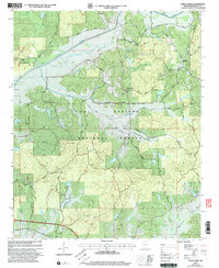
2000 Map of Chilli Creek
USGS Topo · Published 2003About this map
The Holly Springs National Forest encompasses the majority of this Benton County landscape, where small rural communities like Bethel and Pine Grove are defined by their proximity to the winding Tippah River. The terrain is characterized by numerous hollows and hills, such as Renick Hill and Richmond Hollow, with a network of local roads including Tippah River Road and Pine Grove Road connecting scattered family homesteads and local landmarks.
Find a feature on this map
60 named features on this map. Tap any name to fly to it.
Don’t see what you’re looking for? This feature index may not catch every label — zoom into the map to look around manually.
Map Details
Editions of this 2000 Chilli Creek Map
This is the sole edition of this map. No revisions or reprints were ever made.
Other maps of this area

1944 · Potts Camp
USGS Topo · 1:62,500

1945 · Potts Camp
USGS Topo · 1:62,500

1950 · Ashland
USGS Topo · 1:62,500

1953 · Holly Springs
USGS Topo · 1:62,500

1955 · Blue Mountain
USGS Topo · 1:62,500

1956 · Tupelo
USGS Topo · 1:250,000

1958 · Tupelo
USGS Topo · 1:250,000

1964 · Holly Springs SE
USGS Topo · 1:24,000
1969 · Holly Springs
USGS Topo · 1:62,500
1982 · Blue Mountain
USGS Topo · 1:24,000