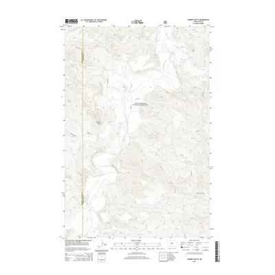
2014 Map of Chimney Butte
USGS Topo · Published 2014About this map
Chimney Butte stands as a prominent landmark in this Badlands landscape, where the Little Missouri National Grassland covers a complex system of draws and creeks. The winding Little Missouri River carves through the center of the sheet, joined by numerous seasonal drainages including Custers Wash, Merrifield Cr, and Tepee Cr. This 2014 survey documents the modern industrial footprint of the Medora Oil Field, which sits northeast of the river.
Find a feature on this map
20 named features on this map. Tap any name to fly to it.
Don’t see what you’re looking for? This feature index may not catch every label — zoom into the map to look around manually.
Map Details
Editions of this 2014 Chimney Butte Map
This is the sole edition of this map. No revisions or reprints were ever made.
Other maps of this area

1953 · Dickinson
USGS Topo · 1:250,000

1957 · Dickinson
USGS Topo · 1:250,000

1961 · Rocky Ridge
USGS Topo · 1:62,500

1962 · Tracy Mountain
USGS Topo · 1:24,000

1962 · Fryburg NW
USGS Topo · 1:24,000

1970 · Medora
USGS Topo · 1:24,000
1979 · Buffalo Gap Campground
USGS Topo · 1:24,000
1979 · Chimney Butte
USGS Topo · 1:24,000

1979 · Square Butte
USGS Topo · 1:24,000

1979 · Bullion Butte
USGS Topo · 1:24,000