
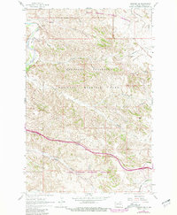
1962 Map of Fryburg NW
USGS Topo · Published 1964About this map
Theodore Roosevelt National Memorial Park dominates this North Dakota badlands landscape, where the Little Missouri River carves through deep drainage basins. In the early 1960s, the terrain was characterized by its unique geological features, including the notable Burning Coal Vein and the Painted Canyon Overlook. The map captures a moment of infrastructure development, specifically the construction of a new 2-lane highway cutting across the southern portion of the park near Sheep Creek.
Find a feature on this map
30 named features on this map. Tap any name to fly to it.
Don’t see what you’re looking for? This feature index may not catch every label — zoom into the map to look around manually.
Map Details
Editions of this 1962 Fryburg NW Map
2 editions found
Other maps of this area

1953 · Dickinson
USGS Topo · 1:250,000

1953 · Watford City
USGS Topo · 1:250,000

1957 · Dickinson
USGS Topo · 1:250,000

1957 · Watford City
USGS Topo · 1:250,000

1962 · Tracy Mountain
USGS Topo · 1:24,000

1962 · Fryburg NE
USGS Topo · 1:24,000

1962 · Fryburg
USGS Topo · 1:24,000

1963 · Gorham SW
USGS Topo · 1:24,000

1963 · Gorham SE
USGS Topo · 1:24,000

1967 · Watford City
USGS Topo · 1:250,000