
1963 Map of Gorham SW
USGS Topo · Published 1964About this map
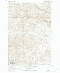
Theodore Roosevelt National Memorial Park borders the southern edge of this North Dakota landscape, where the deeply eroded badlands of Billings County transition into high plateau grazing lands. The drainage pattern of the area is defined by a network of seasonal watercourses, including Ash Coulee in the north and the meandering Franks Creek through the center. These creeks create a complex topography of ridges and draws that influenced the sparse settlement of the region during the early 1960s. Rural educational life is represented by the isolated Stevens Sch near the center of the sheet, while local industry is noted at the Scoria Pit near the southern boundary. The landscape is further marked by cattle-country landmarks such as Dawsons Waterhole and the headwaters of Government Creek, illustrating the reliance on scattered water sources in this semi-arid environment.
Find a feature on this map
10 named features on this map. Tap any name to fly to it.
Don’t see what you’re looking for? This feature index may not catch every label — zoom into the map to look around manually.
Map Details
Editions of this 1963 Gorham SW Map
2 editions found
Other maps of this area

1953 · Dickinson
USGS Topo · 1:250,000

1953 · Watford City
USGS Topo · 1:250,000

1957 · Dickinson
USGS Topo · 1:250,000

1957 · Watford City
USGS Topo · 1:250,000

1962 · Fryburg NE
USGS Topo · 1:24,000

1962 · Fryburg NW
USGS Topo · 1:24,000

1963 · Gorham NW
USGS Topo · 1:24,000

1963 · Gorham SE
USGS Topo · 1:24,000

1963 · Gorham
USGS Topo · 1:24,000

1967 · Watford City
USGS Topo · 1:250,000