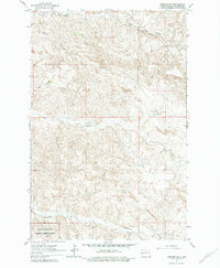
1963 Map of Gorham SW
USGS Topo · Published 1979About this map
Theodore Roosevelt National Memorial Park anchors the southwestern corner of this Billings County landscape, where the badlands topography begins to transition into the drainage basins of the Missouri River system. The 1961 aerial photography reveals a sparsely populated ranching territory defined by deep coulees and draws, such as Ash Coulee and Dawsons Waterhole Draw. Education in this remote stretch was centered at the Stevens Sch, while local industry and road materials were sourced from the Scoria Pit. The intricate water network, including Franks Creek, Wolf Creek, and Government Creek, dictates the placement of the unimproved dirt tracks and section lines that cross the high plateaus between the breaks. This survey captures the rural infrastructure of western North Dakota before significant modern development, showing the original boundaries of the memorial park and the isolated homesteads typical of the era.
Find a feature on this map
9 named features on this map. Tap any name to fly to it.
Don’t see what you’re looking for? This feature index may not catch every label — zoom into the map to look around manually.
Map Details
Editions of this 1963 Gorham SW Map
2 editions found
Other maps of this area

1953 · Dickinson
USGS Topo · 1:250,000

1953 · Watford City
USGS Topo · 1:250,000

1957 · Dickinson
USGS Topo · 1:250,000

1957 · Watford City
USGS Topo · 1:250,000

1962 · Fryburg NE
USGS Topo · 1:24,000

1962 · Fryburg NW
USGS Topo · 1:24,000

1963 · Gorham SW
USGS Topo · 1:24,000

1963 · Gorham NW
USGS Topo · 1:24,000

1963 · Gorham SE
USGS Topo · 1:24,000

1963 · Gorham
USGS Topo · 1:24,000