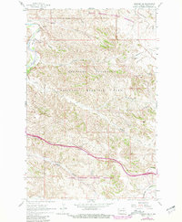
1962 Map of Fryburg NW
USGS Topo · Published 1981About this map
The Little Missouri River carves through a landscape of plateaus and steep washes in this section of Billings County, as documented by the Geological Survey during the 1960s and updated with late-1970s revisions. Much of the terrain is defined by the Theodore Roosevelt National Memorial Park and the surrounding Little Missouri National Grassland. The map reveals the tension between conservation and industry, showing the development of the Scoria Oil Field and the Burlington Northern railroad alongside landmarks like Scoria Point and the Burning Coal Vein. Significant landmarks for local history include named water sources like the Mike Auney Flowing Well and Boicourt Spring. Higher elevations such as Buck Hill provide vantage points over the complex drainage patterns of Paddock Creek and Jones Creek. The arrival of Interstate 94 and the presence of the Painted Canyon Overlook signal the area's transition into a prominent destination for travelers and researchers studying the Badlands.
Find a feature on this map
27 named features on this map. Tap any name to fly to it.
Don’t see what you’re looking for? This feature index may not catch every label — zoom into the map to look around manually.
Map Details
Editions of this 1962 Fryburg NW Map
2 editions found
Other maps of this area

1953 · Dickinson
USGS Topo · 1:250,000

1953 · Watford City
USGS Topo · 1:250,000

1957 · Dickinson
USGS Topo · 1:250,000

1957 · Watford City
USGS Topo · 1:250,000

1962 · Tracy Mountain
USGS Topo · 1:24,000

1962 · Fryburg NE
USGS Topo · 1:24,000

1962 · Fryburg
USGS Topo · 1:24,000

1962 · Fryburg NW
USGS Topo · 1:24,000

1963 · Gorham SW
USGS Topo · 1:24,000

1963 · Gorham SE
USGS Topo · 1:24,000