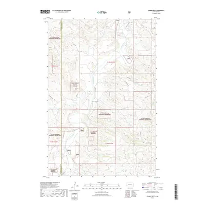
2018 Map of Chimney Butte
USGS Topo · Published 2018About this map
Little Missouri National Grassland dominates this portion of the Badlands, where the Little Missouri River carves a winding path across the landscape. The river's influence is evident in the dense network of drainage features like Custers Wash, Plumely Draw, and Dantz Cr. This late-2010s survey shows a sparsely populated area defined by large federal tracts and the legacy of early ranching and homesteading, anchored by the namesake Chimney Butte. Cultural markers are few but significant for local history, notably the Harmon - Tetly Cem located near Merrifield Rd. The network of backroads, including W River Rd and Tracy Mountain Rd, follows the difficult topography of the river breaks. This map provides a look at the modern management of this western North Dakota territory, where public land boundaries meet the original township and range system.
Find a feature on this map
31 named features on this map. Tap any name to fly to it.
Don’t see what you’re looking for? This feature index may not catch every label — zoom into the map to look around manually.
Map Details
Editions of this 2018 Chimney Butte Map
This is the sole edition of this map. No revisions or reprints were ever made.
Other maps of this area

1953 · Dickinson
USGS Topo · 1:250,000

1957 · Dickinson
USGS Topo · 1:250,000

1961 · Rocky Ridge
USGS Topo · 1:62,500

1962 · Tracy Mountain
USGS Topo · 1:24,000

1962 · Fryburg NW
USGS Topo · 1:24,000

1970 · Medora
USGS Topo · 1:24,000
1979 · Buffalo Gap Campground
USGS Topo · 1:24,000
1979 · Chimney Butte
USGS Topo · 1:24,000

1979 · Square Butte
USGS Topo · 1:24,000

1979 · Bullion Butte
USGS Topo · 1:24,000