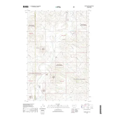
2020 Map of Chimney Butte
USGS Topo · Published 2020About this map
The Little Missouri River snakes through the heart of this North Dakota landscape, carving a complex network of drainages across the Little Missouri National Grassland. The map reveals a remote ranching and conservation environment where the high point of Chimney Butte stands as a prominent landmark. Along the western edge, the border between Golden Valley County and Billings County follows the section lines, bisecting a terrain defined by deep erosional features like Plumley Draw and Custers Wash.
Find a feature on this map
33 named features on this map. Tap any name to fly to it.
Don’t see what you’re looking for? This feature index may not catch every label — zoom into the map to look around manually.
Map Details
Editions of this 2020 Chimney Butte Map
This is the sole edition of this map. No revisions or reprints were ever made.
Other maps of this area

1953 · Dickinson
USGS Topo · 1:250,000

1957 · Dickinson
USGS Topo · 1:250,000

1961 · Rocky Ridge
USGS Topo · 1:62,500

1962 · Tracy Mountain
USGS Topo · 1:24,000

1962 · Fryburg NW
USGS Topo · 1:24,000

1970 · Medora
USGS Topo · 1:24,000
1979 · Buffalo Gap Campground
USGS Topo · 1:24,000
1979 · Chimney Butte
USGS Topo · 1:24,000

1979 · Square Butte
USGS Topo · 1:24,000

1979 · Bullion Butte
USGS Topo · 1:24,000