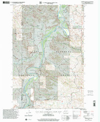
1997 Map of Chimney Butte
USGS Topo · Published 2001About this map
Little Missouri National Grassland encompasses this corner of the Badlands, where the Little Missouri River carves a winding path through the North Dakota landscape. The map records a series of prominent cattle operations along the river valley, including the Custer Trail Ranch, Maltese Cross Ranch, and McCutchen Ranch. These ranch names represent a deep local history of settlement and land use in the river bottoms. The topography is dominated by iconic landmarks such as Chimney Butte and Sentinel Butte, while evidence of natural resource extraction appears in several Oil Well and Oil Wells locations scattered throughout the drainages. Smaller tributaries like Merrifield Creek, Davis Creek, and Coal Creek break the terrain into a network of draws and ridges. A localized Cem and isolated Grave sites provide specific points of interest for genealogists tracing early families in the region near the Golden Valley and Billings county line.
Find a feature on this map
33 named features on this map. Tap any name to fly to it.
Don’t see what you’re looking for? This feature index may not catch every label — zoom into the map to look around manually.
Map Details
Editions of this 1997 Chimney Butte Map
This is the sole edition of this map. No revisions or reprints were ever made.
Other maps of this area

1953 · Dickinson
USGS Topo · 1:250,000

1957 · Dickinson
USGS Topo · 1:250,000

1961 · Rocky Ridge
USGS Topo · 1:62,500

1962 · Tracy Mountain
USGS Topo · 1:24,000

1962 · Fryburg NW
USGS Topo · 1:24,000

1970 · Medora
USGS Topo · 1:24,000
1979 · Buffalo Gap Campground
USGS Topo · 1:24,000
1979 · Chimney Butte
USGS Topo · 1:24,000

1979 · Square Butte
USGS Topo · 1:24,000

1979 · Bullion Butte
USGS Topo · 1:24,000