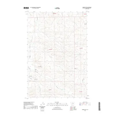
2020 Map of Chimney Butte
USGS Topo · Published 2020About this map
Chimney Butte rises as a prominent landmark within the northern reaches of the Bull Mountains in this modern topographic study of Musselshell County. The landscape is defined by a complex network of drainages and seasonal watercourses, including Fattig Cr and Fishel Cr, which have carved deep ravines and coulees into the high plains. A series of named valleys such as Carters Coulee, Y Bar Coulee, and Tepee Coulee illustrate the localized geography of the ranching country north of the Musselshell River. Access to this remote rangeland is provided by a grid of rural routes including W Musselshell Rd and S Fattig Creek Rd, which follow the contours of the creek beds and ridges. The map preserves the specific land management divisions of the Public Land Survey System, showing the township and range lines that have governed local property boundaries since the homesteading era.
Find a feature on this map
22 named features on this map. Tap any name to fly to it.
Don’t see what you’re looking for? This feature index may not catch every label — zoom into the map to look around manually.
Map Details
Editions of this 2020 Chimney Butte Map
This is the sole edition of this map. No revisions or reprints were ever made.
Other maps of this area

1954 · Roundup
USGS Topo · 1:250,000

1958 · Roundup
USGS Topo · 1:250,000

1963 · Musselshell
USGS Topo · 1:24,000

1963 · Delphia
USGS Topo · 1:24,000

1979 · Roundup
USGS Topo · 1:100,000

1979 · Corey Flat
USGS Topo · 1:24,000

1979 · Gage NE
USGS Topo · 1:24,000

1979 · Chimney Butte
USGS Topo · 1:24,000
1980 · Steamboat Butte
USGS Topo · 1:24,000

1980 · Cherry Spring
USGS Topo · 1:24,000